🇮🇳 India's #1 Authentic Geotagging App – 500K+ Downloads

GPS Map Camera – Stamp Photos with
Exact GPS Location, Date & Time.

Download GPS Map Camera – the free geotagging app that auto-stamps your field photos with accurate GPS coordinates, tamper-proof atomic timestamp, live satellite map overlay, project notes, and company logo. The #1 GPS camera app trusted by engineers, surveyors, and government agencies worldwide.

500K+ Active GPS Camera Users
4.9 ★ Google Play Rating
100% Tamper-Proof Verified
📍

Exact GPS Coordinates

28.6139° N, 77.2090° E

🕒

Atomic Timestamp

Network Synced & Locked
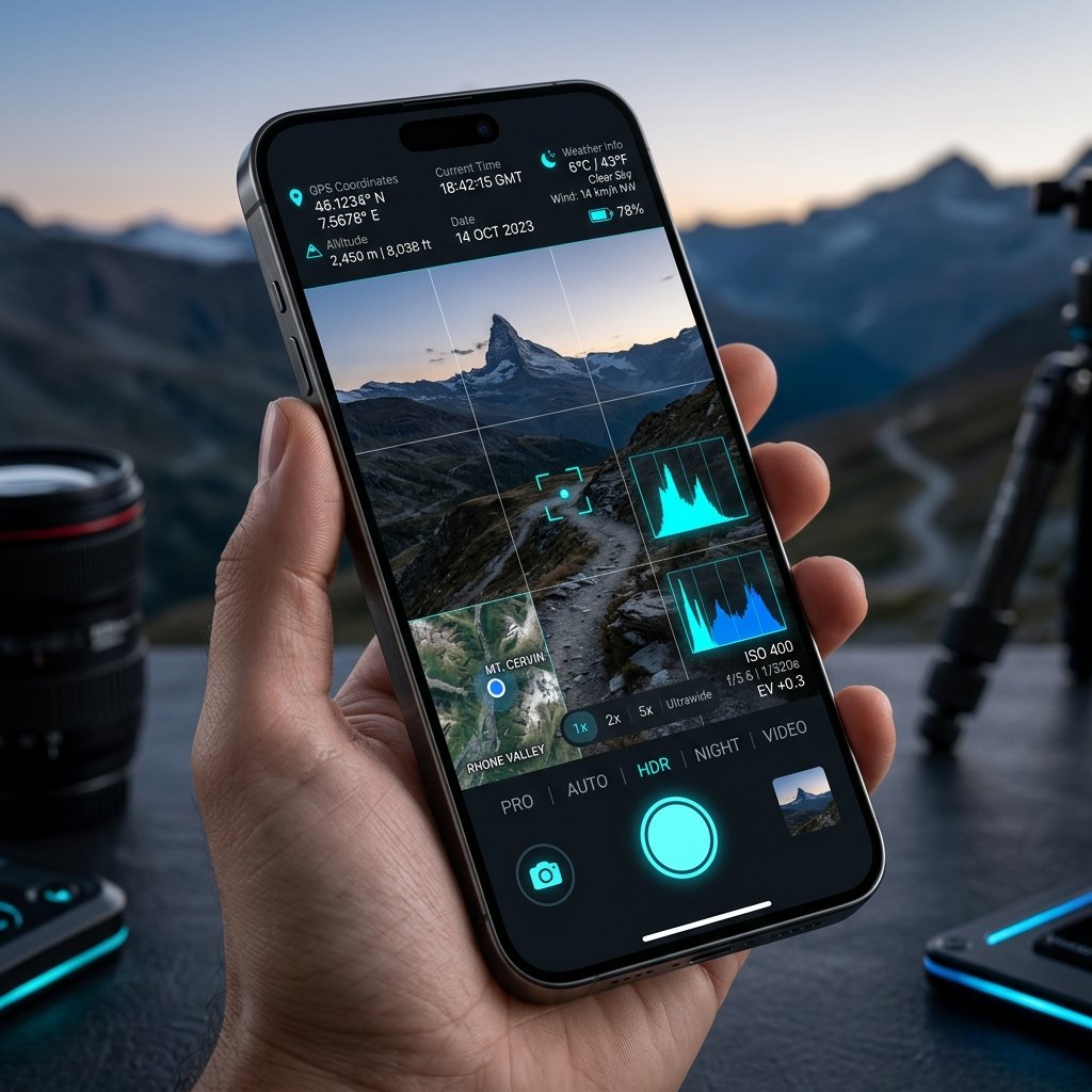
GPS Map Camera App – Live GPS Stamp on Photo with Coordinates and Timestamp
About the App

What is GPS Map Camera?

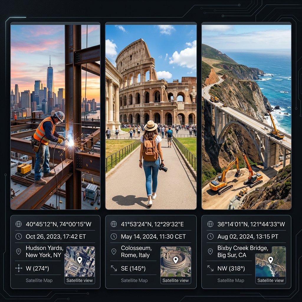
GPS Map Camera (package ID: com.geotagginglocationonphoto.gpsmapcamera) is a professional GPS camera app that overlays exact location data, date, time, and map directly onto your photographs. Unlike standard phone cameras, GPS Map Camera pulls coordinates from multi-constellation satellites (GPS, GLONASS, Galileo, BeiDou) and fetches tamper-proof atomic timestamps from global NTP servers.

The result is a photo that functions as irrefutable legal evidence — with burned-in GPS coordinates that cannot be edited, deleted, or spoofed after the fact. This is why GPS Map Camera is the mandatory field documentation standard for 500,000+ civil engineers, government PWD departments, real estate valuers, insurance adjusters, and delivery fleets worldwide.

  • 📍 Sub-meter GPS accuracy from 4 satellite constellations
  • 🕒 Tamper-proof atomic clock timestamp (NTP synced)
  • 🗺️ Live satellite, street & hybrid map overlay on photo
  • 🔐 SHA-256 cryptographic EXIF hash verification
  • 📝 Custom project notes, inspector ID & company logo
  • 📶 Works fully offline in remote areas without internet
  • 💸 100% free to download on Google Play
Live Interactive Engine

Customize Your GPS Photo Stamp

Try the exact geotagging template engine powering the GPS Map Camera mobile app. Adjust map modes, timestamp formats, and custom notes in real time.

GPS Map Camera Stamp Preview – GPS Location Photo Stamp Example
📍28.6139° N, 77.2090° E | Alt: 216m
🕒2026-07-12 14:45:12 (UTC+5:30)
📌Connaught Place, New Delhi, India
📝Project: Highway Construction Inspection #409
VERIFIED PROOF
GPS MAP CAMERA

🛠️ GPS Map Camera Stamp Parameters

Configure your GPS stamp exactly as needed for municipal surveys, construction reports, or client documentation.

Why Professionals Choose GPS Map Camera

Designed for Total Field Accuracy

Whether you are a civil engineer, government inspector, or real estate agent — every GPS Map Camera stamp is engineered for verified authenticity.

🛰️

High-Precision GPS Triangulation

GPS Map Camera uses multi-constellation satellite signals (GPS, GLONASS, Galileo, BeiDou) coupled with Wi-Fi & cellular triangulation to lock your exact latitude and longitude within 1.5 meters — even in dense urban areas.

🔒

Network Atomic Time Sync

The GPS Map Camera app prevents EXIF date tampering by pulling real-time atomic clock timestamps directly from secure NTP servers. No one can backdate or change your photo's time — ever.

📑

Edit & Customize Every Stamp

In GPS Map Camera, you can edit and customize your stamp with project names, inspector IDs, company logos, true-north compass direction, altitude, and weather conditions — all burned directly onto your high-resolution photo.

Step-by-Step Guide

How to Download GPS Map Camera

Get GPS Map Camera free on your Android or iPhone in under 60 seconds.

1
🛍️

Open Google Play

On your Android phone, open the Google Play Store.

2
🔍

Search "GPS Map Camera"

Type GPS Map Camera in the search bar. Look for our orange pin logo.

3

Verify the App ID

Confirm the package ID is com.geotagginglocationonphoto.gpsmapcamera to ensure it is genuine.

4
⬇️

Tap Download – It's Free!

Tap Install or Get. GPS Map Camera is 100% free — no payment or subscription required.

▶️ Download GPS Map Camera – Google Play
Trusted Across Industries

Who Uses GPS Map Camera?

From downtown construction sites to remote agricultural fields, our app is the standard for visual documentation.

🏗️

Engineers & Construction

Civil and structural engineers use GPS Map Camera to document daily site progress, verify material deliveries, and track structural milestones. The atomic timestamp prevents subcontractors from submitting backdated invoices, while the GPS coordinates ensure repairs are made at the exact required chainage.

📐

Surveyors & Land Mapping

Professional surveyors supplement their RTK rovers with our app to provide visual ground-truthing. A stamped photograph of a boundary marker or control point provides immense legal clarity and perfectly calibrates aerial photogrammetry models.

🏛️

Government Work & Audits

Municipalities mandate the use of GPS Map Camera for government work to eliminate "ghost work" fraud. Contractors repairing public infrastructure must submit photos with verified coordinates and timestamps to prove public funds are spent correctly.

🌾

Agriculture & Crop Audits

Agronomists tracking crop diseases across massive farms use the app to pinpoint outbreaks. Insurance adjusters rely on the tamper-proof timestamps to verify storm damage claims instantly, preventing fraud.

🏠

Real Estate & Valuation

Property valuers and real estate agents document property conditions before tenant move-ins. The uneditable date stamp provides a legally admissible "before and after" record for dispute resolution.

🚚

Logistics & Delivery

Last-mile delivery fleets capture proof-of-delivery photos. If a package is claimed missing, the delivery company can produce a stamped photo proving the exact location and time the package was dropped off.

GPS Map Camera Knowledge Base

Latest GPS Camera Guides & Case Studies

Explore real-world guides on how GPS Map Camera transforms construction verification, government audits, and legal documentation.

GPS Map Camera – GPS Camera for Construction: Managing Subcontractors with Visual Proof Engineering & Construction
📅 2026-07-12 • By David O'Connor (UI/UX Architect)

GPS Camera for Construction: Managing Subcontractors with Visual Proof

How general contractors utilize a GPS Camera for Construction to track daily site progress, manage subcontractor payments, and avo...

Read GPS Camera Guide →
GPS Map Camera – GPS Camera for Government Work: Enforcing Transparency in Public Projects Government & Municipal
📅 2026-07-12 • By Sarah Jenkins (Forensic Data Analyst)

GPS Camera for Government Work: Enforcing Transparency in Public Projects

Why municipal corporations and federal agencies mandate a GPS Camera for Government Work to eliminate corruption and ensure accoun...

Read GPS Camera Guide →
GPS Map Camera – GPS Camera for Agriculture: Precision Farming and Crop Insurance Agriculture & Agronomy
📅 2026-07-12 • By Marcus Chen (Logistics Director)

GPS Camera for Agriculture: Precision Farming and Crop Insurance

Discover how a GPS Camera for Agriculture is revolutionizing crop disease tracking, yield estimations, and insurance claim validat...

Read GPS Camera Guide →
Frequently Asked Questions

GPS Map Camera FAQ

Got questions about GPS Map Camera? Find instant answers below.

Is GPS Map Camera free to download?

Yes! GPS Map Camera is completely free to download on Google Play (com.geotagginglocationonphoto.gpsmapcamera). All core GPS stamping features are free with no subscription needed.

What is GPS Map Camera used for?

GPS Map Camera is used by civil engineers, government inspectors, surveyors, insurance adjusters, delivery drivers, real estate agents, and agricultural field teams to stamp photos with exact GPS location, date, and time for verified field documentation.

Can I edit the GPS stamp text in GPS Map Camera?

Yes. You can edit the project note, inspector ID, company logo, map style, and timestamp format inside the app before capturing. The GPS coordinates and atomic timestamp, however, are auto-generated and cannot be faked.

What is the package ID for GPS Map Camera?

The official Google Play package ID for GPS Map Camera is com.geotagginglocationonphoto.gpsmapcamera. Always use this ID to verify you have the genuine, tamper-proof version.

How do I add a GPS location stamp to my photo?

Simply download the GPS Map Camera app, grant location and camera permissions, and open the viewfinder. The app automatically fetches your current latitude, longitude, and atomic time, overlaying them onto your screen. Press the shutter button, and the stamp is permanently burned into the image.

Is GPS Map Camera acceptable as legal evidence?

Yes, in most jurisdictions. Because the app utilizes Network Time Protocol (NTP) to prevent date spoofing and fetches location directly from satellite hardware rather than editable settings, the resulting photographs provide a cryptographically secure chain of custody suitable for audits and legal disputes.

Does the app work without an internet connection?

Absolutely. GPS Map Camera is designed for remote field work. While the map overlay may require a cache, the core GNSS tracking hardware in your phone communicates directly with satellites, meaning you can still get highly accurate coordinate stamps in the middle of a desert without cellular data.

What is the difference between a Timestamp Camera and a GPS Camera?

While some apps only offer a Timestamp (which can sometimes be spoofed if they rely on the phone's internal clock), a true professional GPS Map Camera combines NTP-secured atomic timestamps with multi-constellation GPS coordinate tracking, providing both temporal and spatial verification simultaneously.
View Full GPS Map Camera FAQ →

Download GPS Map Camera Free.
Start Geotagging in 60 Seconds.

Join over 500,000 engineers, surveyors, and inspectors who use GPS Map Camera — the #1 GPS photo stamp app — every single day to capture tamper-proof field evidence.

▶️ Download GPS Map Camera – Google Play

📲 Download GPS Map Camera – Free for Android

Join 500,000+ engineers, surveyors, and professionals who use GPS Map Camera to stamp photos with verified GPS location, atomic timestamp, and custom project notes. 100% free. No subscription required.

▶️ Download GPS Map Camera on Google Play